 Catalogue IFL
Boundaries
Type of resources
Available actions
Topics
Keywords
Contact for the resource
Provided by
Formats
Representation types
Update frequencies
status
Scale
Resolution
-
This dataset is the definitive set of locality boundaries for the state of Victoria as defined by Local Government and registered by the Registrar of Geographic Names. The boundaries are aligned to Vicmap Property. This dataset is part of the Vicmap Admin dataset series.
-
-
-
This dataset is the definitive set of locality boundaries for the state of Victoria as defined by Local Government and registered by the Registrar of Geographic Names. The boundaries are aligned to Vicmap Property. This dataset is part of the Vicmap Admin dataset series.
-
This dataset is the definitive set of locality boundaries for the state of Victoria as defined by Local Government and registered by the Registrar of Geographic Names. The boundaries are aligned to Vicmap Property. This dataset is part of the Vicmap Admin dataset series.
-
-
-

The ISO19115 metadata standard is the preferred metadata standard to use. This template is multilingual with a default language set to english. Other language could be used to translate part of the metadata record. Main language is define in metadata section. Other languages could be added to metadata section / locale element.
-
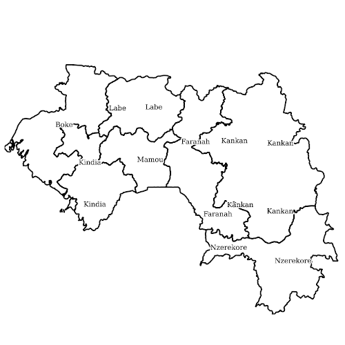
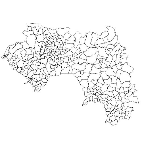
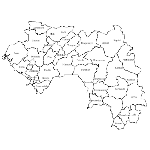
LLg makes available in the IFL OpenStreetMap thematic datasets for French-speaking West African countries, available either with their original attributes ("tags"), mostly in English, or in a version where over 1400 categorized attributes are translated into French, from existing translations in the OSM wiki and JOSM editor. The list of translated tags can be found here: https://gitlab.com/leslibresgeographes/osm-tags-translation/-/blob/main/LLG_OSM_SQL_translation_EN_FR_GitLab.tsv These two datasets each represent 16 layers covering 8 different themes, as well as a "Planet" theme grouping all OSM objects on the territory in order to recreate its own themes. Each theme is presented in the list of related resources below. The attribute table for each theme presents both the most common OSM keys and an hstore field containing all the attributes of each object. --------------------------------------------------- These OpenStreetMap datasets are updated daily via imposm from the raw .obf data supplied by Geofabrik, and then translated. Until these updates are complete, the old layers remain available. --------------------------------------------------- To access the data, scroll down to "Sources datasets" and open the country file to download the desired theme(s): - either directly from the country sheet, the entire territory in one of the available formats - or from a MapStore context, on a part of the territory to be drawn by yourself or chosen within the administrative boundaries of the country in question. Demonstration videos are available here: https://llg-collabora.ethibox.fr/s/owY8DQTQpgDr8sw
-
The OSM Administrative Boundaries theme has a single layer (osm_fr_limite_admin_hstore in French, osm_en_admin_boundary_hstore in English) containing all the polygonal objects of the selected territory bearing the OSM admin_level or boundary keys translated into French by niveau_administratif and frontiere. This layer displays in its attribute table the most commonly used keys in OSM for this theme (names, type, administrative level, wikidata, wikipedia, etc.), as well as a hstore field containing all the OSM tags of the object. It is produced daily by LLg via imposm from the raw data offered by Geofabrik. Consult the parent page for more information, access to the data on available areas or to other themes.