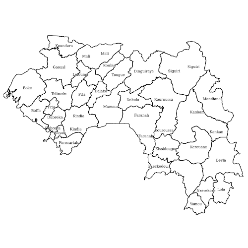
Limites adm2 - Préfectures - Guinée - 20210503
Ce jeu de données vectorielles polygonales contient les limites administratives de rang 2 (préfectures) de la République de Guinée. Il provident de humdata.org et a pour source OCHA West and Central Africa (ROWCA). Il est sous licence Creative Commons Attribution for Intergovernmental Organisations.
Simple
- Date ( Publication )
- 2021-04-23
- Presentation form
- Digital map
- Status
- Completed
Publisher
Publisher
- Maintenance and update frequency
- As needed
- Continents, countries, sea regions of the world. Continents, countries, sea regions of the world. ( Place )
-
- Guinea
- PNLTHA - Guinée PNLTHA - Guinée ( Theme )
-
- Dubréka
- Boffah
- épidémiologie
- glossine
- Forécariah
- FIND
- trypanosomiase
- health
- PNLTHA
- OpenStreetMap
- OSM
- LLg
- IRD
- KoboToolBox
- LAV
- ODbL
- Les Libres Géographes
- open data
- Trypa-NO!
- humdata
- limites administratives
- Access constraints
- License
- Use constraints
- License
- Other constraints
- ODbL
- Spatial representation type
- Vector
- Denominator
- 5000
- Metadata language
- fr
- Character set
- UTF8
- Topic category
-
- Boundaries
N
S
E
W
))
- Reference system identifier
- WGS 1984
- OnLine resource
-
Guinee_PNLTHA_hors_osm_public:GN_limites_adm2_prefectures_ocha_20210503
(
OGC:WMS
)
Limites adm2 - Préfectures - Guinée - 2021050
- OnLine resource
- Fichier Geopackage ( FILE:GEO )
- OnLine resource
- Fichier ESRI Shapefile ( FILE:GEO )
- OnLine resource
- Fichier GeoJSON ( FILE:GEO )
- Hierarchy level
- Dataset
gmd:MD_Metadata
- File identifier
- 6b8300c2-3c36-4185-a1d8-7ebac119b7bb XML
- Metadata language
- fr
- Character set
- UTF8
- Parent identifier
- Geographical data of the Trypa-NO! project in Guinea - parent metadata f693259b-1306-4b1f-a7ec-1f9401dfb461
- Date stamp
- 2022-03-12T22:08:02
- Metadata standard name
- ISO 19115:2003/19139
- Metadata standard version
- 1.0
Originator
Point of contact
Overviews

Provided by

Associated resources
Not available
 Catalogue IFL