 Catalogue IFL
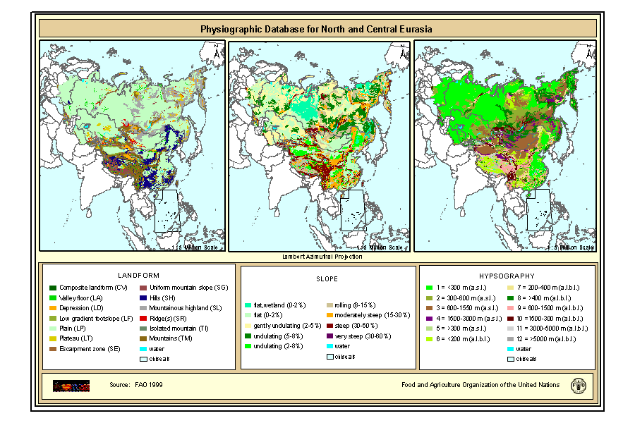
Physiographic Map of North and Central Eurasia (Sample record, please remove!)
Simple
- Date ( Publication )
- 1999-10-01
- Edition
- First
- Presentation form
- Digital map
- Status
- Completed
- Maintenance and update frequency
- As needed
- Keywords ( Theme )
-
- physiography, soil
- Keywords ( Place )
-
- Eurasia
- Access constraints
- Copyright
- Use constraints
- Copyright
- Spatial representation type
- Vector
- Denominator
- 5000000
- Character set
- UTF8
- Topic category
-
- Geoscientific information
- Begin date
- 2000-01-01T04:29:00
- End date
- 2008-01-08T04:29:00
))
- Supplemental Information
- The maps are included in the SOIL and TERRAIN Database for Northern and Central EURASIA CD-ROM , which contains also the Soil map of North and Central Eurasia, reports and databases. Copies of this CD-Rom can be ordered from: Sales and Marketing Group FAO, Viale delle Terme di Caracalla, 00153 Rome, or by email to Publications-sales@fao.org. The terms and definitions used in the Physiographic database are based on the procedures manual for ?Global and National Soils and Terrain Digital Databases (SOTER)?, prepared by UNEP, ISSS, ISRIC and FAO and published by FAO as World Soil Resources Report #74 Rev1 (1995). Refinements were made in China as part of the preparation of a physiographic map for Asia, work carried out by G. van Lynden for FAO as part of the ASSOD project.
- Reference system identifier
- Lambert Azimuthal Projection
- Topology level
- Abstract
- Geometric object type
- Complex
- OnLine resource
-
phy.zip
(
WWW:DOWNLOAD-1.0-http--download
)
Physiography of North and Central Eurasia Landform (Gif Format)
- OnLine resource
-
GEONETWORK:phy_landf_7386
(
OGC:WMS
)
Physiography of North and Central Eurasia Landform
- OnLine resource
-
GEONETWORK:phy_slope_7386
(
OGC:WMS
)
Physiography of North and Central Eurasia Slope
- OnLine resource
-
GEONETWORK:phy_hypso_7386
(
OGC:WMS
)
Physiography of North and Central Eurasia Hypsography
- Hierarchy level
- Dataset
gmd:MD_Metadata
- File identifier
- 78f93047-74f8-4419-ac3d-fc62e4b0477b XML
- Character set
- UTF8
- Date stamp
- 2007-11-06T12:10:47
- Metadata standard name
- ISO 19115:2003/19139
- Metadata standard version
- 1.0
Overviews
Provided by
